Do you want to get involved in mapping? You can start your own mapping activity by taking the following steps:
Create a free public account using an ArcGIS login:
An ArcGIS public account is a free account that is available for individuals to create and share content with limits on usage. Follow the steps below to create an ArcGIS public account using an ArcGIS login:
From the website, click the Sign In link at the top of the site or access the sign in page directly from https://www.arcgis.com/home/signin.html.
Once you have signed up for the cloud-based software, please go ahead try to make a map from County Health Rankings data. Please click on the link
Click Create an account. For more detailed instruction, please see more steps after the video. Just a note that the video below used a Python-callable program.
Free Account GIS Instructions Continued from Above:
Under Create a free public account, click Create an ArcGIS Public Account.
Type your first name, last name, and email address. Retype your email address to confirm.
Read the ArcGIS Online terms of use and privacy policy. Check the boxes to agree to the terms and policy and click Next.
ArcGIS Online sends you an email with a link to continue the creation of your account.
Open the email and click the link provided or copy it to your browser's address bar and press Enter.
Read carefully at Username and Password Requirements
Select a security question and type an answer. This information is used to verify your identity in the event you forget your password.
Click Create account.
You are automatically signed into the website.
Above is a sneak peek into one of the more complex techniques in geographically weighted regression. Now we will take a step back and understand why we should study in geographic terms! But first meet our team below:
Researchers

John Huth MS, GISP is an official GIS Professional who has over two decades of experience in mapping. He is currently a part of the COVID-19 Social Change Grant Research Team at Walden University. He has been recognized by the Wildlife Society as an upcoming Scientist and has extensive experience as a geospatial analyst and has worked on forestry, wildlife occupancy, and home range estimation used artificial intelligence (AI) to discover species habitats, conducted remotely sensed chemical impact studies, performed geospatial time-series studies, and completed several zoonotic geospatial disease predictive cartography projects and study the spread of fungal pathogens spread via weather events. His most recent projects with the Department of Defense (DoD) through The United States Geological Survey (USGS) have emphasized spatial wildlife epidemiology describing geographic variations in disease with a particular focus on environmental, behavioral, socioeconomic, genetic, and genetic infectious risk factors.
Sri Banerjee MD, PhD has nearly 20 years of experience in geospatial mapping technologies. He helps students apply geospatial techniques in doctoral level research. Several former students who have learned geospatial techniques from Dr. Banerjee now actively use this in the field. During the early 2000's, he was involved in applying mapping and was involved in HIV tracking and surveillance at the Centers for Disease Control and Prevention. Since then, Dr. Banerjee earned a Master's Degree in Geospatial Analysis from Johns Hopkins Bloomberg School of Public Health. Additionally, he has worked on several original research studies relating environmental health, cancer epidemiology, and geospatial research. He presented his novel findings at the prestigious Joint Statistical Meeting with the American Statistical Association. He has designed curricula and provided expertise as to how to understand educational disparities through a geospatial context. Recently, in 2021 Dr. Banerjee started a new series on applications of geospatial research.
Geographic Considerations
By: John Huth, MS and Sri Banerjee, PhD
Why think geographically?
Well, let's think about patterns that we know, vary geographically. For starters, we know that weather varies. The northern latitudes are known to get colder than the equatorial latitudes. So further north you go, the colder it gets. This affects migratory patterns of geese and how far they fly. However, now start thinking about patterns of disease. I have studied diabetes extensively and below is an example of pattens regarding prevalence of diabetes within the United States.
Where does the terminology come from?
An argument can be made that any cartographic analysis throughout history is a Geographic Information System (GIS). However, the term has gained acceptance in the 1990s in parallel with the increased amount of computer-based information and processing available. GIS is often considered anything related to location that refers to data and software. Put differently; a GIS is a computer system that analyzes and displays geographically referenced information that uses some data to attach a unique location.
What do location questions look like?
In reality, most of the information in our world contains a location reference, and many of our questions refer to a referenced site. Examples include:
Where is the closest hospital?
Where was the rock sample collected?
Where are all of the city's fresh produce located?
Where do you live?
Therefore, a GIS analysis allows the user to ask questions involving where something is and how location relates to other things.
How can you apply this in ecology?
Suppose a rare plant is observed in different areas. In that case, a GIS analysis might reveal that the plants are all on north-facing slopes above or below a specific elevation and get more than five inches of rain each year. GIS maps can then display all areas with similar conditions, so researchers know where to look for the rare plants. Additionally, a GIS analysis can look beyond human sight to observe phenomena in other light spectrums. Also, predictions can be made by knowing a collection of spatial information. For example, if the location of several farms is plotted on a map that uses a specific fertilizer, using streams, elevations, and rainfall would illustrate which streams are most likely to carry that fertilizer downstream.
How can you use this to study social determinants?
You can map various types of social determinants on a single map with overlays and spatial joins. For instance, one can easily map the location of food deserts within the city and look for the association with neighborhood built environment. Similarly various diseases can be studied in relationship to the various social determinants. Many of the vulnerable populations or historically marginalized groups were the ones hit the hardest during the pandemic. The following video is a lecture I delivered surrounding geospatial consideration around COVID-19. Please visit this link for detailed county level information.
Here is a file that contains multiple measures of county level of data. This file can be used for analysis after some data cleaning for a variety of types of geospatial data manipulation.

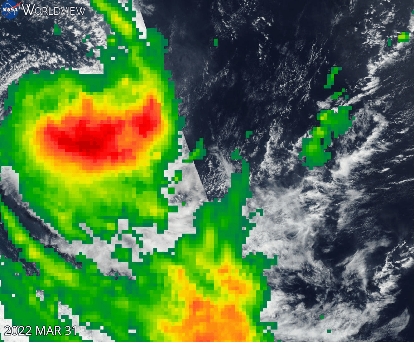
I created the image above to show how time lapse satellite imagery can provide visuals of forest fires and even hurricanes (Cyclone Halima-April 1 is when it starts to disintegrate). Please notice how the forest fire appears on January 29 in Portugal. This forest near Braga, Portugal is disappearing. You can alternatively go back to the original maps in the following website.
Also, you can follow the tutorial that I have created for the map. This is illustration of tempero-spatial patterns which I have created a tutorial for below: